Guide 09
Engineering report & PDF
Prepare a traceable journal-style document from the active session.
A review-ready engineering document
Report / Print turns the current session into a journal-style A4 report. It gives your team a shared summary of the evidence, where to investigate next and what was actually measured—without rebuilding charts and tables manually.
Use Executive for a focused review; use Full technical for a deeper handover with traceable tables. The report can include a completed VDT Run when available, but never treats a route preview as measured or completed prediction evidence.
| Report content | Benefit to your review |
|---|---|
| Session and measurement mandate | Check dataset, time range, GPS audit, operator, device and scope before interpreting results. |
| RF and service metrics | See signal strength/quality, throughput and available LTE/NR evidence with their units. |
| Charts and route figures | Locate trends and weak segments and relate them to recorded geography. |
| Mobility and technical tables | Review logged handovers, cell transitions, weak segments and available cell/PCI evidence. |
| Contents, figure and table indices | Jump to a relevant section in the preview and keep document navigation in the saved PDF. |
| Notes, registers and provenance | Preserve reviewer context, detailed evidence and source limitations for the next engineer. |
Open and define the mandate
In Overview, choose Report / Print. Select Full dataset or Active filters, the report edition and language. Enter a title, preparer and notes when relevant; empty identity fields do not invent an engineer name.
Review published date, dataset identities, GPS audit and sample range. Executive condenses the findings; Full technical includes the available engineering detail. Enable full registers when complete sample/event tables are required.
Interface walkthrough
From evidence to a document
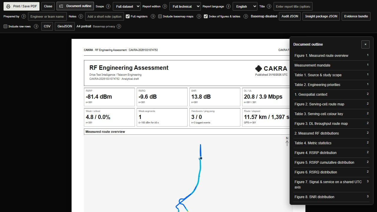
Wait until the report is ready, choose Print / Save PDF, then inspect the saved document. This example uses a schematic map.
Basemaps and privacy
Basemaps start enabled. Tile providers receive requests for the approximate route area, not the raw log or signal values. Turn basemaps off in the report toolbar if that boundary is unacceptable. Keep map attribution visible.
Wait for map/figure generation to finish before printing. Unavailable imagery is labelled as a schematic, not presented as a captured basemap. A snapshot captures the viewed map, not a complete site survey.
Save and verify the PDF
Choose Print / Save PDF, select Save as PDF in the browser dialog, A4 portrait and the intended page range. Disable the browser’s own headers/footers to avoid duplicate URL/date text. Keep background graphics enabled for the intended report colors.
Open the saved PDF and verify contents links, page numbering, figure captions, table continuations and selected scope. The report stays white/navy even if the workspace is dark. Browser/PDF-viewer behavior varies; inspect the actual exported file.
Audit JSON, CSV and GeoJSON are separate machine-readable downloads. Keep them with the source log to support later verification; a PDF alone is not a substitute for all coordinates and samples.
A practical handover checklist
Before exporting, confirm the dataset and filters, fill the title/preparer/notes, choose the edition and review the contents. Include full registers only when the recipient needs detailed sample/event tables. Select available workspace snapshots if a particular map view helps explain a finding.
Wait for figures and layout to finish. Inspect the first page, a weak-segment page and the final register page. Save the PDF and open it again to check internal links, selected scope and table continuation. Share its Audit JSON, CSV or GeoJSON alongside it when the recipient needs reusable data.