Guide 12
Import an RNO configuration
Populate VDT from one reviewed, structured technical package.
Download a ready-to-import practice file
Download the complete configuration JSON and the user quickstart below. The JSON is a valid practice package with six LTE/NR sectors, explicit units, radio/antenna settings, a timed route and small environment examples. It is synthetic, not an operator’s real network or a verified road survey.
Use it unchanged for your first import review. For your own work, replace the practice values with your authorized, verified configuration; preserve the field names, units and versions. The field guide explains the supported structure.
| File part | What to review |
|---|---|
| format / schemaVersion / units | Package identity, supported version and explicit measurement units. |
| project | Revision, preparer, publication date, notes and whether the package is synthetic. |
| scenario.sites | Each sector’s unique identity, coordinates, radio and antenna settings. |
| scenario.settings / thresholds | Propagation/receiver/mobility assumptions and ordered classification thresholds. |
| scenario.routeCoordinates | Latitude/longitude points and optional consistent elapsedMs timing. |
| environment attachments | Optional terrain/buildings, their height references and provenance. |
Download, review, Apply
After downloading a configuration, follow the review and Apply workflow below. Keep the original package so you can check what was imported.
In VDT choose Import configuration and select the JSON. Review project revision, sector count, LTE/NR, positions, power, antenna angles, route, environment and warnings. Expand Complete validated input for the full parsed fields.
Cancel leaves the editable configuration unchanged. Apply replaces editable inputs and clears their current preview/result; it retains the archived completed Run. Prediction execution and remote Save remain separate actions.
Interface walkthrough
Review before replacing settings
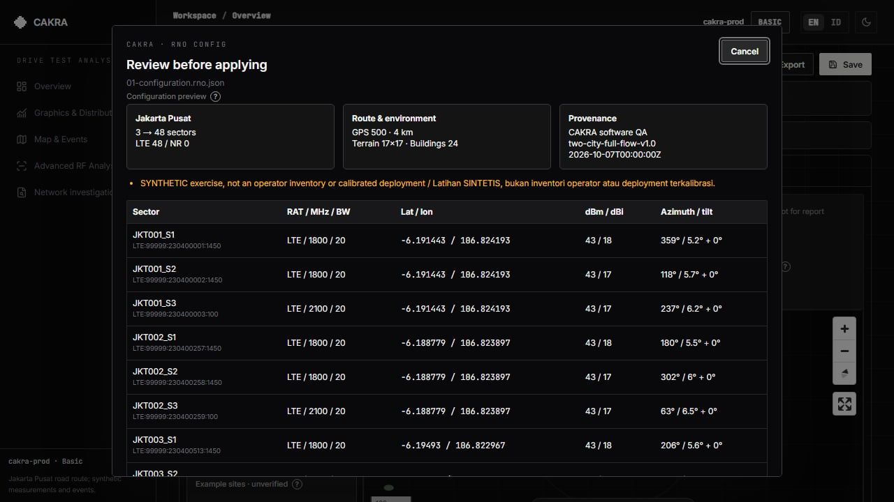
Apply replaces editable inputs and clears the current preview/result, without prediction, credit charge or remote save. Cancel leaves inputs unchanged.
Check meanings, not just numbers
The package uses format cakra-rno-config and schemaVersion 1, with explicit units, project provenance and a versioned scenario. Numeric values must be numbers, not strings such as "43 dBm". Unknown configuration keys are rejected.
Supported upload size is at most 10 MB; sectors 1–50, route vertices 2–5000 when supplied. Route elapsedMs must be present on all vertices or none; explicit timing starts at zero and increases strictly.
| Input | Engineering meaning |
|---|---|
| txPowerDbm | Conducted total carrier power, before gain/feeder loss; not EIRP or per-RE power. |
| gainDbi / heightM | Peak gain in dBi, not dBd; antenna height above local ground, not sea level. |
| Azimuth / tilt | Azimuth clockwise from north; electrical and mechanical tilt are separate degrees. |
| LTE / NR | Review frequency, BW, numerology and equipment authorization separately. Supported FR1 combinations are validated. |
| Terrain / buildings | Embedded regular-grid terrain CSV and bounded building GeoJSON need provenance and a consistent vertical datum. |
Vendor datasheets and real field data
Arbitrary PDF, Word and Excel documents are not automatically interpreted. An RNO engineer must map their verified values and semantics into the JSON contract first. Native CAKRA scenario JSON is also supported.
Vendor .msi antenna patterns have a separate supported import path in VDT. Preserve the original complete RNO package: native scenario JSON alone does not carry every terrain/building attachment. A real equipment model cannot make invented BTS locations or uncalibrated propagation into actual network coverage.
A larger road-route exercise
For an advanced exercise, download the Jakarta RNO test pack below. It reuses the prepared public-road planning benchmark: about 61.6 km router distance, not an exact reconstruction of the 51.18 km screenshot. Manufacturer reference equipment is documented, but BTS positions and radio settings are design assumptions—not an operator inventory or measured coverage.
Extract the ZIP first. To see the full route, import 01-full-route/CAKRA-Jakarta-LTE-B3-Overview.rno.json. The NR-n1 overview is a separate scenario. For denser local RF exercises, use C01…C16 in 02-rf-clusters/LTE-B3 or their NR-n1 counterparts. Read START-HERE.md and the field-test/coverage/source documents in 04-engineering before Run.
Do not upload the ZIP, master planning inventory or route GeoJSON as a configuration. Use one supported .rno.json file at a time. Each cluster starts a separate prediction; do not sum its mobility counts into a claimed continuous drive. Preserve the route and equipment limitations when sharing results.